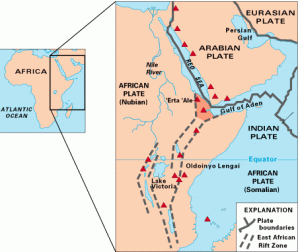
Kasese is the capital of Kasese District in west Uganda and the largest town of the Rwenzururu Kingdom. Historically it was a large copper mining area and the western most point on the British railroad stretching from Mombasa through Nairobi to Kampala and out through Uganda to Kasese. Along these rail routes laborers from India and supplies from Europe were shipped into Africa and tea and coffee, among other exports were shipped back east to the port at Mombasa. Lining the western edge of Kasese town are the lush green foothills of the Rwenzori Mountains. The name Rwenzori comes directly from the Rwenzururu Kindgom, with Rwenzururu translating basically to “Kingdom of the Snows” much like the literal meaning of “Himalaya.” The Rwenzori Mountains first appear in western records when in 150AD Greek philosopher Ptolemy made claims of a snowcapped mountain range in the heart of Africa feeding the Nile river, referring to this range as the “Mountains of the Moon.” It wasn’t for almost another 2000 years before the mountains were rediscovered by western explorers. Henry Stanley, who first circumnavigated the nearby lake Victoria, first spotted the Rwenzori Mountains in 1888 after the notoriously fickle clouds in this humid tropical rainforest decided to part one day finally exposing the snowcapped mountain peaks. The tallest peak was later named after Stanley, when the Duke of Abruzzi led the first ascent up the Rwenzori’s in 1906. Furthermore, we now know today that Ptolemy was actually correct in his assertion and that the melting snows from the Rwenzori glaciers do feed the Nile as they wash down the mountains pouring through the Mubuku river first into Lake George before winding around the mountains range into Lake Albert which cascades down into the Nile river through Murchison falls and continues its journey northward.
The Rwenzori Mountains are a wonderfully unique feature of this planet. Creating the border between west Uganda and the eastern Congo, this 75 mile mountain range running basically on the equator reaches altitudes up to 5109m making it the tallest mountain range in Africa and the only glacial range in all of Africa as the other African glaciers lie atop dormant freestanding volcanoes (Kilimanjaro, Mt Kenya). Due to the location, elevation and climate with around 2500mm (100in) of annual rainfall the flora is incredibly diverse ranging from tropical rainforest and tropical agriculture in the foothills at the base to bamboo and heath forests, the afro-alpine zone, and finally the glacial snow zone reaching up to the rocky peaks. The plant life found in the Afro-Alpine here in the Rwenzori is found nowhere else in the world outside of Africa and even within the continent only at elevations of about 3500m and above. Although this unique afro-alpine flora can be seen on other great African climbs like Kilimanjaro, Mt Kenya, or Mt Elgon, nowhere can it be seen in the same size and concentrations as here in the Rwenzori’s. I can only describe this place as Dr Suess meets “Where the Wild Things Are” in nature… It is truly a nature lover’s paradise.
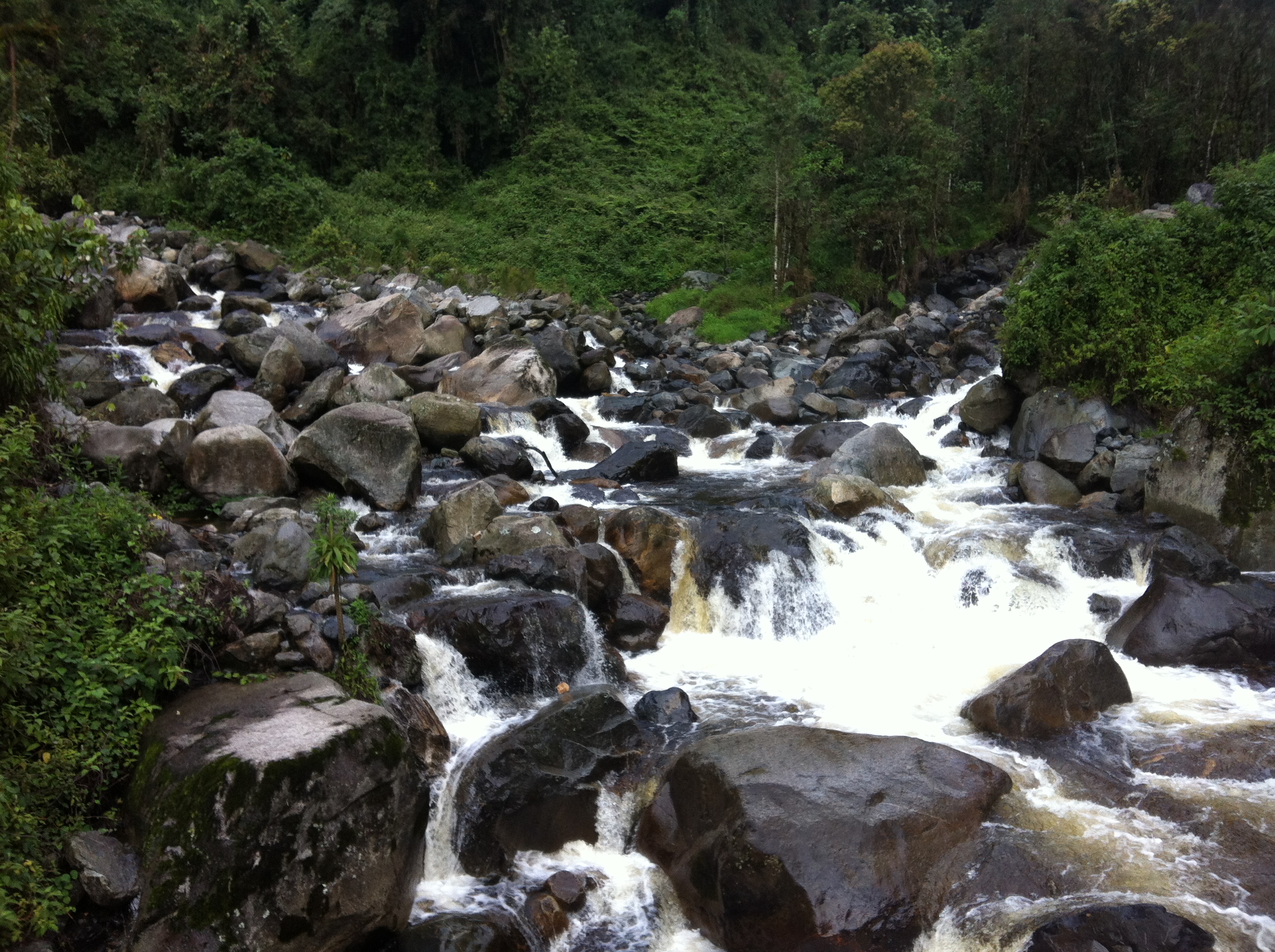
To reach the trailhead it is a 30 minute motorcycle ride from Kasese up a long dirt road to a small outpost called Nyakalengija perched in the foothills of the Rwenzori’s. On the ride up there is a small market town where locals sell fresh produce & fruits from their farms during the week. Small farm plots can be seen dotting the surrounding foothills and pushing all the way up to the park entrance gate. Even on the steep hilly slopes crops of banana, maize, beans, potatoes and other fruits can be seen, irrigated by the regular rainfall of this tropical forest. Part of the reason for national parks in places like the Rwenzori’s is to protect the environment from the clear-cutting of native forest for agricultural land that has been so common around the world leading to issues with soil erosion and potential complications with pollution of important water sources. I spent a night camping by the trail head and preparing for the beginning of the 6 day circuit hike in the morning. The small camp provided views up the valley towards the heart of the Rwenzori range, but like so many other days in this place the mountain tops were enveloped in a thick cloud cover. It seemed that rain might be a common occurrence over the next few days on the mountain. I went to explore the surrounding area before dinner and discovered that besides one other low cost campsite there was a brand new eco-lodge funded by USAID. The camp included luxury stone eco-cabins all built with local materials and fitted with wood floors, stone fireplaces, and balconies perched overlooking the Mubuku River. The place was very well put together and the bar staff was very friendly and excited to see a visitor as Im not sure how many people have ever decided to spend the $200 per person per night to stay in this new eco-lodge, especially given the fairly hectic roads that would bring you here to the side of this mountain. From the camp a short walk through the forest brought you down to the raging Mubuku River, fresh with waters flowing down from the snowcapped mountains. This river was dammed further down the mountain side to bring electricity to Kasese town but even the small camp that I stayed in had its own micro-turbine capable of generating enough electricity to power the camps kitchen and a few light bulbs.
 We had a leisurely start the next morning as the first day was the shortest. The day’s hike wound through the warm tropical forests, the trail lined with ferns and covered with a thick canopy including some massive trees easily a hundred years old. We crossed the Mubuku river a few times with the sounds of its rushing waters never far away and all the while climbing around 1000m to reach the first nights camp at Nyabitaba at 2600m. Just before reaching camp the first good viewpoint opened up allowing us to see out towards the eastern flatlands from which we were rising. After just a few hours of hiking we were completely immersed in tropical forest with nothing but thick forest cover along the steep mountain slopes being visible in any direction. Tracing the lines of the hillsides before us you could count 5 different hills and valleys laying out to the horizon. The open air and views back to the east were offset by the grey weather that lay ahead with the mountain tops still hiding behind a layer of clouds. The trail became ever muddier as we approached the camp and the signs of fresh rain were all around. We had missed the rains that day and were even greeted in the evening with a clear view of the portal peaks, a few jagged rocky outcroppings just across the valley north of our camp. Forest rangers were stationed here at this camp equipped with automatic firearms, a week’s worth of food and supplies, and a cave to sleep under for their week long rotation, supposedly to protect trekkers against the possibility of Elephants, however they stayed only at the first camp and did not continue deeper into the forest. I had to assume that the armed guards posting here at the only trail entrance in and out of this valley had to do with fact that the Congolese border was a mere 20 miles to the west through these mountains, and that rebel groups had previously occupied the Congolese side of these mountains.
 The next morning we had an earlier start beginning by 7am for our much longer 900m ascent to the John Matte camp at 3500m. At the beginning of the hike we first descended to cross the Mubuku River one more time at the point where the Bujuku valley meets the Mubuku valley joining two rivers to create the Mubuku River, the accumulation of all of the waters exiting these two valleys. From this bridge we began our steep climb up the valley through forests with jungle vines dangling from the evergreen tree canopy above. As we continued ever higher we passed through a maze of bamboo forest before being opened up to the heath forest where aging trees adorned a common tree moss known conveniently as “old man’s beard.” The light airy arrays of pale green moss dangled from old branches on hundreds of surrounding trees contrasting nicely with the backdrop of grey skies and adding to the mystique among the twisted, gnarled & knobby trees. This moss is a sign of a
 healthy forest ecosystem as it begins the slow and steady ecological process of reclaiming organic matter from the trees for the fertile forest floor. The forest giveth and the forest taketh away. As we continued up the open valley you could begin to see open rock cliffs lined with a thick blanket of red & yellow moss. Climbing ever higher, the flora only got larger, thicker, more colorful and weirder as the mystique continued to grow. We crossed through dense boggy forest sections that would completely engulf you for a time, transporting you into a place you thought existed only in your childhood imagination before kindly returning you to the outside world. Thick green & yellow moss carpeted the forest floor and fallen trees. Large mossy bulges clung to the twisted knobs of trees taking on a life of their own. The flash of deep red from the wings of the Rwenzori Turaco and constant swirl of bird calls around you only enhanced the sensations of the forest.
 On the muddy trails your rain boots could sink up to the ankle with any step. Some boggy areas were simply unpassable and so horizontal ladders of wet and slippery wood had been constructed to aid the path. Climbing beyond the mossy forest we emerged to a flat portion of the valley where we would be spending the night at the John Matte camp. We had reunited with the Bujuku River which rushed past our camp trailing away down the valley. We were now perched at a point above the valley floor where we could watch the show of thick clouds and mist rolling in up the valley swallowing everything in their path. After some time the dissipating clouds opened up the world below again anew while small trails of fresh cloud condensed and formed indefinitely along the edges of the rocky peaks. Again we were lucky enough to be greeted by a clear view of the surrounding ridgelines as the sunset approached. The highest peaks of the Rwenzori’s were first visible in the distance from this camp with three peaks of Mt Stanley showing their glory just beyond the rushing river in the foreground. There isn’t a much better feeling in the world than resting after a long days hike on a nice patch of grass on the mountainside enjoying the everlasting dance of nature’s being.
 That night the rains finally caught up with us and at 3500m it was cold. Freezing cold. Hat, jacket and socks on inside the sleeping bag cold. For being on the equator in Africa it was surprisingly colder than my trek not more than a month back in the Himalaya of north India. Luckily I had brought plenty of tea to keep me warm. The next morning we arose to greet a cloudy, rainy, freezing cold day. To avoid venturing out into this weather we waited around after breakfast drinking tea for a few hours and sitting by the slightly redeeming warmth of the fire under an open air cover with a corrugated iron roof and four wall sheets rising about half way to the roof. By around noon, the rain had slowed to a steady drizzle and we made the choice to venture on. Today we were marching on
  through the largest bog areas on the whole circuit known as the Upper & Lower Bigo Bog. The bogs are flattened stretches surrounded by streams and have accumulated tons of water from the melting snows above. With any wrong step you can quickly be submerged in the thick wet mud up to your thighs. Besides the boardwalks that have been constructed through two particularly deep and tricky 200m portions the best way to make it through these boggy areas is to play hopscotch on the top of the tussocks bushes that are so abundant in this ecosystem. The tussocks grass is a small shrub with a solid core that is capable of holding the weight of a person as opposed to the moss and other grasses that happily give way letting you sink gently into the mud. Either way it is inevitable that you will go boot deep into the mud at some point which is why it is entirely crucial to wear rain boots for much of this hike. As we entered Bigo Bog, the surrounding area was clouded in mist, and a light drizzle lapped gently against my forehead and face. Crossing through the first section of the bog, growths of giant lobelias began to spring up all around. The young lobelia is an agave-like plant with densely packed leaves arranged in a perfect spiral around a central cup which holds the bud. The leaves are a deep purple on the outside and retain a dark green on the inner side of the leaf facing the central bud. These peculiar plants have adapted a great resilience in order to survive in the harsh cold, rain & snow along with the tropical heat that envelops this part of the mountain throughout the year. They hold small pockets of water & secreted slime in their watertight center allowing the top layer of liquid to freeze overnight on the coldest nights, like a thin frozen layer above a winter pond, leaving the bud below submerged in water and protected from the dangers of the freeze. The flower of this plant grows up in a column from the central bud in a symmetrical flowering cluster rising perfectly from the spiraled leaves below with some of the plants reaching 3 meters in height.
 After a short climb we reached the second bog and as we entered this perfectly flat boggy valley the mist and rain lifted to expose the sharp valley walls rising up a few hundred meters on each side. This section reminded me a lot of the flat Yosemite Valley surrounded by the shear granite walls, except for instead of pine & spruce trees, there were giant lobelias and instead of flat granite walls, there was wet mossy walls painted yellow & red. I imagine that over geologic time this area was once filled with a massive glacier, like Yosemite, that carved these walls and has slowly been receding over the years creating the bogs, rivers, streams and high altitude lakes that remain today. After crossing this second bog we started the final push for the day climbing 500m up to Bujuku Lake and our camp for the night. As we began the ascent we saw the giant groundsels for the first time. Groundsels have a woody trunk that can grow up to 8m with
  a wide green leafy top. With each flowering, the plant will fork causing a new branch to grow with a new leafy green top emerging from the branch. Most of the groundsels appear to have between one and four branches and allow their leaves to weep down onto the trunk in order to help maintain heat for the plants core. Like the giant lobelias, the giant groundsels also have learned the ability to store pockets of water overnight allowing the top layer to freeze as protection. What is incredible is that some of these groundsels are easily 6m (20ft), however they are said to grow between 1-5cm (.4-2in) annually meaning that some of these giant groundsels could be 200-300 years old! The ascent brought us through an entire alpine forest of these
  groundsels and these plants would stay with us for much of the rest of the climb. We emerged from the groundsel forest to the placid Bujuku Lake laying quietly beneath the towering rock formations of Mt Stanley, Mt Speke, and Mt Baker. The clouds were still enveloping the heights of the peaks, but by now you could feel how close we were to the summits. Looking back down into the valley you could clearly see the flat valley we had just emerged from. We went to sleep that night tired but hopeful for good weather in the morning. We would be crossing the 4400m Scott Elliot Pass with the best chance for great views of the surrounding snowcapped peaks.
I rose just before dawn. It was a crisp, cold morning in the valley. Sunrise hadn’t yet reached the valley although the light emanated from outside the mountain walls. Another warm cup of tea in the morning helped me to greet the day and the enchanting peaks that towered above. Finally visible were the glacial snows of both Mt Stanley and Mt Speke on the opposite side of the valley. A thin layer of cloud covered the mountain tops, and Mt Baker to the east was still completely engulfed, but a clear blue sky was visible to the west where just beyond the western saddle in between Mt Stanley and Mt Speke was a long descent into the forests of northeastern Congo. Today however, we were headed south, leaving Mt Speke behind and climbing 400m to cross the pass between Mt Stanley and Mt Baker before descending again to the shores of another high altitude lake, Lake Kitandara marking the border of Uganda & the Congo. After about an hour’s climb we had reached a viewpoint with Mt Speke and Mt Stanley looming overhead, however upon reaching, clouds had enveloped the entire valley. It’s amazing how quickly weather can change in the mountains and especially in a humid place like the Rwenzori’s the fog can roll in at any instant. The fog certainly adds to the mysticism of this enchanting place. As you are climbing an almost vertical rock scramble surrounded by giant groundsels, fallen trees blanketed with fluffy patches of moss and steep rock walls covered in red & yellow moss, the fog only serves to contain your focus to your immediate present, blocking out any external distractions. The fog leaves a cool mist on your skin and its transient nature keeps you ever aware that the environment around you is as alive as you are. Within about 20 minutes of reaching the viewpoint, our rest stop quickly turned into another lively display of the fog battling against the encroaching rays of light. Slowly the fog began to dissipate and little by little the lake in the valley below showed its face again. Slowly, slowly the fog lifted from the base of the mountains flowing back down the valley like a stream with some pouring up over the saddle to the west. The cool air of the fog gives way to a feeling of warmth as the sun’s rays gently make their way into the surroundings. To watch this progression in time lapse video would be a beautiful thing, but to be able to perceive and embrace these gradual transformations in real time is something special and something that can only really be achieved in a natural setting such as this over an
  extended period of time. You just can’t rush the sunrise. So after almost an hour of enjoying the fog streams, Mt Speke finally decided to show its full glory. To be fair these mountains are not the majestic Himalaya, but there is something uniquely different about the surroundings that make snowcapped mountains here above this tropical forest on the equator majestic in their own way. The climb from Bujuku Lake up to the viewpoint and then on to Scott Elliot Pass went from steep stair stepping to a full on rock scramble with some light bouldering in stretches. From the top of the pass the world opened up again to the south showing for the first time the Mubuku valley, views out to the neighboring ridgeline, and an up close view of the Mt Stanley glacier with a thin waterfall pouring down from the melting ice. The melting snows and glaciers are feeding lakes and rivers on both sides of this pass only to rejoin later at the base of the valley where we began our trek. That afternoon we rambled down into the Mubuku valley and
  arrived at one of the most beautiful camp sites I have ever been witness to, Kitandara Lake. This high altitude lake, secluded at 4000m was filled with crystal clear and ice cold, glacial waters. The lake was surrounded by thick forest, steep moss covered rock faces and Mt Stanley & Mt Baker loomed just behind. The clear waters of the lake glistened in the sunlight and as the sun began to set the lakes surface displayed a perfect reflection of the surrounding mountains. Pure, pristine beauty. We slept within 10 meters of the shoreline and the stars here were some of the clearest and most beautiful I have ever seen.
 We awoke early again to hike out of Kitandara Lake and over the 4200m Freshfield Pass. The lake was surrounded on all sides by steep rock walls. Our pathway out to the east involved a steep rock scramble straight up the eastern wall of the lake. It was another crisp morning but with crystal clear blue skies surrounding the entire lake. From the top of the wall we could see clearly out west across the forests of the Congo. The glacier of Mt Stanley was still visible across the lake and we were now directly under the glacier of Mt Baker. From here we crossed a wide mossy bog before the Mubuku valley exposed our way down and wide views of the entire valley below covered in yellow moss radiating in the sunlight. The gradual descent seemed to breeze by with the understanding that we had reached our highest peaks for this journey and that it was all downhill from here. The going was still slow with wet and boggy conditions, but by now we had grown accustomed to the careful bog jumping using tussocks plants, rocks and whatever other natural balance points we could find. The final day led our descent literally through a small waterfall and stream bed. Climbing down the wet and slippery rocks turned out to be one of the more physically demanding and challenging parts of the whole trek, but with mindfulness and cautious maneuvering we were down safely. We passed again through the thick mossy forests entering the world of red moss blanketed trees again for just a short time but by the afternoon we had emerged from the forest and after a good wash in the Mubuku River we marched out of the Rwenzori Mountains. In almost an instant we had left behind the enchanting forests of the Rwenzori Mountains and returned to the small town of Kasese to continue the journey ever onwards.